The Lower Mississippi River Water Trail

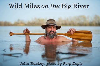
Resistance Radio – Guest: John Ruskey – 10.29.17
John Ruskey is worker bee in the colony of his queen, the Lower Mississippi River. He carves canoes, paints, and guides others into the wildest place remaining in the center of North America, the verdant floodplain of the big river, which reaches fullness in her last thousand miles of free-flowing joy to the Gulf of Mexico. He is author of Rivergator.org, one million words, photos, paintings, maps and videos describing the Mississippi River for paddlers.
RIVER MADE: DEEP INTO THE GUT OF AMERICA BY DAVID ROSS
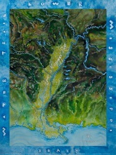
SUSTAINABLE COMMONS: WHAT GOES INTO PAINTING A RIVERGATOR MAP?
Atchafalaya River: The Best Route to the Gulf
Paddlers Guide to the Lower Mississippi
Maps of the Lower Mississippi River
Plan your river canoeing or kayaking adventure with detailed maps of the Lower Mississippi River? Our Maps page has links to maps of the river from St. Francis to Arkansas City, and the best camping along Lower Mississippi Water Trail.
For tips on how to use Google Maps for planning your trip refer to this excerpt from the River Log, Reading Google Maps…Unlike highways which don’t change shape or position with the seasons, the islands of the Mississippi River and their back channels are dramatically affected by water levels. And so the paddler needs to remember that the shapes of low-lying landmarks like the sandbars and wetlands seen on Google Satellite Maps or Google Earth is probably not what they are like on any given day when you are out on the river. more…
Canoe and Kayak Safety
The Mississippi River presents many challenges for paddlers, but when properly approached by experienced paddlers with the right equipment it can be the amongst most rewarding paddling in North America. Rivergator has extensive information about canoe and kayak safety especially on the Mississippi River. Visit Safety under the Paddler’s Guide and get prepared for your Mississippi River adventure.
Camping on the Mississippi River
The best camping on the Lower Mississippi River Water Trail is found within one mile perimeter of the locations listed on this Campsite Map. River campers, please be aware that actual sandbar size & shape very greatly with water level. In the River Log you can read detailed accounts of canoeing, kayaking, paddling and camping on the Lower Mississippi River. Select the area of the River where you’ll be paddling or camping and there are descriptions to help you plan your paddling adventure.
THE RIVERGATOR is a mile-by-mile paddler’s guide written for canoeists, kayakers, stand-up-paddleboarders, and anyone else plying the waters of the Lower Mississippi River in human-powered craft.
The Middle/Lower Mississippi River creates the longest free-flowing water trail in the continental United States, 1155 miles from St. Louis to the Gulf of Mexico.

The name Rivergator is adopted from the best seller The Navigator first published in 1801 by Zadok Cramer, with the hope that Americans will rediscover their “wilderness within,” the paddler’s paradise created by the Middle Lower Mississippi Rivers.
Four year project. Website under construction. Dec 2014: add on St. Louis to Caruthersville and Vicksburg to Baton Rouge. Dec 2015: website completed with the addition of Baton Rouge to the Gulf and the Atchafalaya.
Useful for daytrippers and long distance paddlers alike. Choose your section of the Lower Mississippi River to explore by clicking on one of the sections below. Or click on the full color base map and keep clicking through increasing magnification of maps for details.
The below mileage corresponds to the mile system used on the 2007 US Army Corps of Engineer River Maps.
Click on a section or mile marker below to view the index for that section.
Rivergator News
Missouri Division of Tourism newsletter:
http://news.visitmo.com/paddling-the-lower-mississippi-river/
New Orleans Times Picayune
Mississippi River paddler to extend online guide to include Baton Rouge
Canoe & Kayak Magazine: Why Paddle the Mississippi
by Wolf E. Staudinger
1: The Bluffs
2: International Appeal
3: The Mystery
4: Navigation
5: The Atchafalaya
6: To the Gulf
Ernest Herdon – McComb Enterprise Journal
Colorful Maps Portray Lower Mississippi River Charting the lower Mississippi
Paddlers explore islands, deal with towboat wakes
Canoe passes Buffalo, Lake Mary, Angola Prison
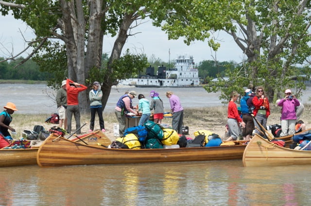
Rivergator 2017 Celebratory Expedition
March 20 – May 10, 2017
Rivergator 2017 Celebratory Expedition Description
Spring 2017 Expedition Info
Spring 2017 Expedition Itinerary
Press Kit


Who is the Rivergator written by?
The Rivergator was written by paddlers for paddlers. Primary author, John Ruskey, has been paddling, photographing, and documenting the islands, landings and channels of the Lower Mississippi River since 1982. A host of big river experts reviewed content and added details including legendary river guide Michael Clark (Big Muddy Adventures, St. Louis) author Ernest Herndon (Canoeing Mississippi, Canoeing Louisiana), and biologist Paul Hartfield (endangered species specialist for the US Fish & Wildlife). Project is coordinated by the Lower Mississippi River Foundation. The Rivergator website is made possible by many partners, including the Walton Family Foundation, which believes in “conservationomics”: lasting solutions that make sense for the economy and the environment.
Book: I Am Coyote
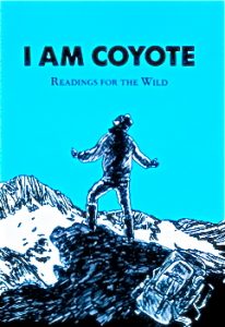 Including Rivergator Excerpt! Most know the Mississippi River as the powerful, coffee-colored waterway that cuts through the center of America, or as the stomping grounds for Mark Twain’s indelible characters. But it is also a viable wilderness thriving right under our noses. In pulling together writings from Muir, Thoreau, Roosevelt, Rivergator, and many, many others, I AM COYOTE makes a strong bid for the ultimate river island campfire anthology.